
As you travel toward Tibet, you see mile posts with the distance from Shanghai, but we think you'll be more interested in the distances from Grimshaw (Canada not Scotland) that Cal has been keeping for us since the beginning of the trip.
N 36.24.23 E 94.53.39 Altitude 2780 meters 9265 km from Grimshaw
The question In everybody's mind was "would we be allowed to enter this province/autonomous region/country?" The Calypso family met our Tibetan guide, Tsewang, in Golmud and with permits in hand and positive thoughts we started the journey south. We passed the first checkpoint just outside of town with no problems but a few km south we encountered road repairs (done by hand by crews of women and men) and two major military convoys - one coming from Lhasa and the other heading in our direction. Interesting fact - even the military trucks are decorated with ribbons and bows. It was slow going through the construction and our first bush camp was still north of Tibet.


.JPG) |
| donkeys not deer |


.JPG) |
| Jason making a concession to the temperatures by wearing a jumper with his flip flops and shorts (Lorri learning Brit/Aussie expressions) |
 |
| Beautiful night skies at this altitude |
N 44.51.34 E 92.56.44 Altitude 4570 meters 9480 km from Grimshaw (altitude and animals)
We were all feeling the effects of altitude sickness - headaches, breathlessness, and nausea as well as a restless sleep. But we packed up camp and continued our journey along the Tibetan plateau. The land is starkly beautiful We've seen a bunch of interesting animals, too, as the road travels through very unpopulated highlands. Wild Tibetan donkeys (pretty brown colour and we mistook them for deer till we enlarged the photos), Himalayan deer and antelope, and cute little rodent things that we named Gregory (gerbil sized) and Henry (small rabbit sized) until our Tibetan guide realized what we were doing and said that Gregory was a Himalayan mole and Henry was a pica. I think we are entertaining him! And there are yaks everywhere (many decorated with prayer flags) - but they are domestic, apparently there are only a few wild ones and they stay at higher altitudes and away from people. Lou and Cal, with the occasional contribution from Nico, continue to see new birds. There were black redstarts, brown cheeked buntings, Himalayan griffons (who win the prize for coolest name), brown headed gulls, hoopies and a whole cast of others who remain nameless.
.JPG)
 |
| Gregory |

.JPG)
.JPG)
Mid morning saw us stopping at the "welcome to Tibet" archway for a photo op. The police check a few km down the road took five hours while passports were checked and higher authorities were consulted. It makes you realize how unusual it is for a western group to travel overland into Tibet. While our guide spent the time in the office, we had lunch, did some pre-dinner prep, played a bit of basketball, entertained the locals and participated in a number of photo ops with officials and passing motorists. Permission was finally granted to continue, and after a quick supper and a very enthusiastic "woo hoo" Calypso and her family were officially welcomed to Tibet.

 |
| Looks like an album cover. Tsewang, Steve, Cal, Jason,Dave, Bruce, Keith, Alicia |
 |
| Teresa, Lou, Tina, Mikkel, Jordan and Mel |

 |
| Setting up camp as dusk is falling. Mikkel and Dave on the roof. |
 |
| The iphone version, just the silouette |
 |
| Sunset at almost 5000 meters |
 |
| Nico's wee tent for the ladies was hastily taken down in the wee hours as the mother of all storms was sending lightening and winds to entertain us. |
N 32.44.48 E 91.52.27 Altitude 4963 meters 9735 km from Grimshaw (more altitude and a birthday)
Getting up in the dark to start a long drive to Lhasa, everybody worked to help each other pack up camp with conversations about the lightening storm that had passed through, the gorgeous sunset and who was dealing with what altitude symptoms. It was a quiet group that hit the truck, but some magic fairies (led by Mark our truck wallah) had found the breath to blow up balloons for Lorri's birthday. Lunch, and birthday cake, were had at a police check that included friendly yak, curious Gregories and the ever present visiting dog.
 |
| Checking out an accident that happened as we passed it |
 |
| Yurts and prayer flags Set up just like a pow wow circle in Northern Alberta |


N 39.39.20 E 91.07.50 Altitude 3677 meters 10089 km from Grimshaw (Lhasa, Buddhism and retail therapy)
After two looong driving days and high altitude bush camps we made it to the Yak hotel in Lhasa. Not a sleepy isolated Tibetan town by any means. The old town (and we are in it) comprises 4% of the city. The rest is bustling Chinese city like the others we have seen. Great comfortable beds, excellent wifi, included breakfast one of the best on our trip (real bacon) and a lovely restaurant next door. We are here for four nights, so lots of time to check out the sights.

 |
| Prayer flags on the roof of our hotel |


.JPG) |
| Two ladies visiting Traditional dresses and lovely hats |
.JPG) |
| Mixing the old and the new. Hill trbesman with traditional hair and beads (coral, turquoise and/or amber) and western shirt and hat |
Top on the list of things to do was to visit the Jokang monastery, one of two UNESCO sites in Lhasa. Built in the 8th century, damaged and rebuilt numerous times over the centuries (most recently following the Cultural Revolution in the 1960s), our guide, Tsewang, used the tour to help us see the intertwining of history, politics and religion for the Tibetan people. Bruce put it so well (thanks Bruce for letting me paraphrase your words) that for us westerners, religion is something that we put on or take off at our convenience. For Tibetans, however, their religion defines their every action.

 |
| These aren't the snow lions (aka Gregories) you will see at the Jokang temple |
1. When you go to the Jokang monastery, look up at the rafter poles around the second floor, or look down into the courtyard from the second floor. Every monastery has snow lions for good luck, but these ones are individually carved by some unknown artist. Like gargoyles in mediaeval European churches, these are all different, and it seems like a whole field of Gregories peering at you!
2. The Potalo palace has all sorts of restored glitz, but watch for the cabinet with hundreds of Buddha statues. Some of them are more than 1000 years old and all of them were carefully hidden by local people to protect them from destruction during the Cultural Revolution.
3. Sera monastery is absolutely worth a visit. The ride on the local bus there and back is prime people watching. It's noted for healing cranky babies and adults with mental illness - when we went through, a smiling monk insisted we needed blessing so we all left with black smudges on our noses!
.JPG) |
| The smudgy nose crew |


 |
| Sera Monastery dogs |
 |
| Potala Palace from the People's Square |
 |
| The ugly frowny figures, sometimes with flames are "protectors" aka good guys |

Lhasa wasn't all monasteries, it was also a great place to stroll the old town and people watch. The markets satisfied everybody's retail therapy needs. And it was hard to decide whether to eat Tibetan, Chinese, or fast food fusion (the word Dico's comes to mind).
 |
| Bandian - traditional married woman's apron. This is hand woven and hand dyed pure wool not the mass produced cotton or polyester for everyday |
 |
| If I could have figured out how to get this home... Yak skull artwork |
 |
| Prayer flags |
 |
| The Buddha's eyes and beads that might be bodhy (sacred fig trees growing around monasteries) but they are hand strung in Shigatze by the monastery, because I watched them being finished. The purse is made in Nepal |

 |
| We all saw this fellow doing the prayer circuit (Kora).There was a complicated set of movements to be done with each step, kneel and then prostrate. Our guide told us that many pilgrims would do this for miles as they walked from their rural village in to the monastery |


.JPG) |
| Coffee break for the street cleaner |
N 28.54.43 E89.36.19 altitude 4037 meters 10208 km from Grimshaw
(Gyantsi, another birthday and a stunning conclusion to the Calypso World Cup Football Pool)
Next, it was off down the Friendship Highway. To get to Gyantsi, we drove narrow twisting roads through beautiful mountains. You could tell we were on the tourist track now, with busloads of Chinese tourists as fascinated by our little group as by the mountain scenery. And at each stop there were enterprising nomads showing off their animals or offering to sell trinkets.

 |
| 5 yuan for a photo. This lady was using a drop spindle to spin wool as she was minding her cows |
 |
| Lou checking out a "bow" (baby cow) |
 |
| Alicia taking a photo of Lorri taking her 5 yuan photo |
 |
| Nico and Bruce |
 |
| Prayer flags on |
 |
| Chinglish |

Of course there was another monastery. Watch for the very ugly/flaming Buddah figures- they are actually protectors, not bad guys. Also, take a walk toward the river and walk the back road. You can get some great photos of the monastery and the fort above it. Imagine, before the Cultural Revolution, that all the empty ground was full of buildings.


 |
| This fort figures in the great game. |

T and T had time for a T (tattoo, that is). But the big social event was Wayne's birthday held at the Gyantsi Kitchen. It was a three white scarf set of birthday wishes and a good time had.


Before we left Gyantsi, we had one more important celebration. Starting in Kyrgyzstan and continuing through China and into Tibet, the Calypso family eagerly followed the World Cup Football. Each morning, our truck wallah, Mark, would post scores. Some of us were more excited to find out what were the categories of the day, some of us cared about our points. There were even an enterprising few who figured out how and where to watch the games live. But like all good things, it came to an end on the truck before leaving Gyantsi. Despite a last minute battle with Steve, Cal managed to hold onto his last place position and be crowned Chumpion. Top place and Champion of the World was never in doubt as Luke, with his excellent skills at playing the odds, had led from the beginning. But Jordan and Jason had been quietly creeping up the ranks. In the end, though, Jordan managed to outstrip the competition to become honored runner up.


N 29.16.23 E 88.53.04 altitude 3815 meters 10187 km from Grimshaw (Shigatze in the rain)
We were in Shigatze for three days to get permits to visit Mt. Everest base camp. Or maybe it was to get permission to travel to the Nepal border. Despite the frequent rain showers, we all managed to find something to do. For some, it was a chance to do a bit more retail therapy, for which Bruce gains the distinction of getting the most spectacular bit of jewelry (to go with the equally lovely ring in Lhasa). Some took advantage of China Post to send their treasures onward, while others found space in luggage. One last monastery, this one the home of the Pachem lama, even though he lives in Beijing. By this time, our guide Tsewang had gotten a feel for the group and was a bit more open on telling the slightly less politically correct but more interesting bits. Like the rumor about monks being bribed with tv in their cells, and... Interesting fact, the kora (pilgrim's walk) is up into the hill and is a great way to people watch, check out animals and see over the old town as you walk back into the market.
 |
| Everywhere in Tibet you would find fabric or painted designs along the roof line. It is to remind people of their nomadic past. Many great quilty ideas. |
 |
| Old not yet retouched designs |
 |
a bit of rebellion here. any time you see snow lions in clouds in Tibet, it is referring to independence. |

 |
the old paintings had their own elegance |


 |
| Local sheep helping to eat the offerings of grain The messages on the rocks were carved/painted and carried to the mountain |
.JPG)
.JPG) |
| Taking photos of tourists taking photos |
 |
| And a local goat |
N 28.34.10 E 87.05.06 altitude 4359 meters (Somewhere near Mt Everest)
It was another long day driving, including a most interesting several hours being part of a major "truck got stuck" incident. Apparently this section gets washed out every spring and then repaired every summer. What made it worse was that the rain we had had in Shigatze had been three days of snow - which brings home how high we are and how brief summer is on the Tibetan plateau. Hint from Lorri - check out Corb Lund's video "The Truck Got Stuck"" to get the feel for the situation. We pulled into the national park with just enough daylight to pitch tents and eat a "home cooked Chinese meal" courtesy of our Chinese guide, Daniel, and cook group one.

 |
| Cow with decorations |


 |
| And here he is! Long telephoto from about 50 km away |
 |
| The best part was the mini bus with hill tribes people. They all got out, figured out how to attach a rope and started pulling. Ladies as well as men. It takes a community... |
N 28.10.10 E 86.50.25 altitude 4991 meters (Everest Base Camp - we made it!!)
We started our day getting tickets to the base camp where we had a perfect early morning view of Mt. Qomolangma himself (for Tibetans, the mountain is definitely a he). Then we started up the road to the tent village we would stay in for the night. Up, up, up then down, down, down as we moved from one valley to the next. Great scenery, local nomads and their animals. Finally just after lunch, we arrived at the tent village where tourists must stay. Vastly overcrowded and under serviced, but the Calypso family made the best of the situation (and used our well practiced bush wee skills), because for some of us this was the highlight of the trip.
 |
| Everest is the middle peak, some is being a little shy (cloud covered) |


.JPG)
It's only a 3 - 4 km walk and less than 200 meter elevation gain but at this altitude, that still means lots of stopping to catch our breath. Some of us chose to enjoy the view from the tents, some of us went up and down fairly quickly (content to see the arch, snap a photo or two) but a few hardy souls communed with the mountain most of the afternoon. Although the mountain had been exceedingly shy and cloud covered all day, later in the evening the clouds lifted giving great views. Interesting fact, the river that is flowing from Everest is a tributary of the Yellow River.
 |
| Behind that cloud is Mt. Qomolangma himself |


Thanks to the weather gods for sending the rains when we were in Shigatze and the blue skies when we visited Everest.

N 28.21.28 E 86.03.44 altitude 4215 meters (Moving down. All things must end - last bush camp and a final Calypso adventure)
Next morning, out the way we came then south on the Friendship Highway. Still the stark mountain passes but we were dropping in altitude. We started to see cows instead of yaks and some vegetation. The streams we crossed are flowing in our direction. The crew and our guides started to talk about finding a really nice spot for our last bush camp. Ever. And perhaps a bit of a party. A lovely green spot by a river was found. Unfortunately, Calypso had other ideas and got stuck up to her front axel in the mud (repeat "the Truck got Stuck" if you wish). After hours of digging determination and a lot of creative "truck unstuck" solutions, we turned in with prayers that tomorrow would be a better day. And it was. With sand mats, rocks in the right places, and an audience of the local nomads, Calypso inched her way back onto the road and we were off toward the Nepal border town of Zangmu.


.JPG)
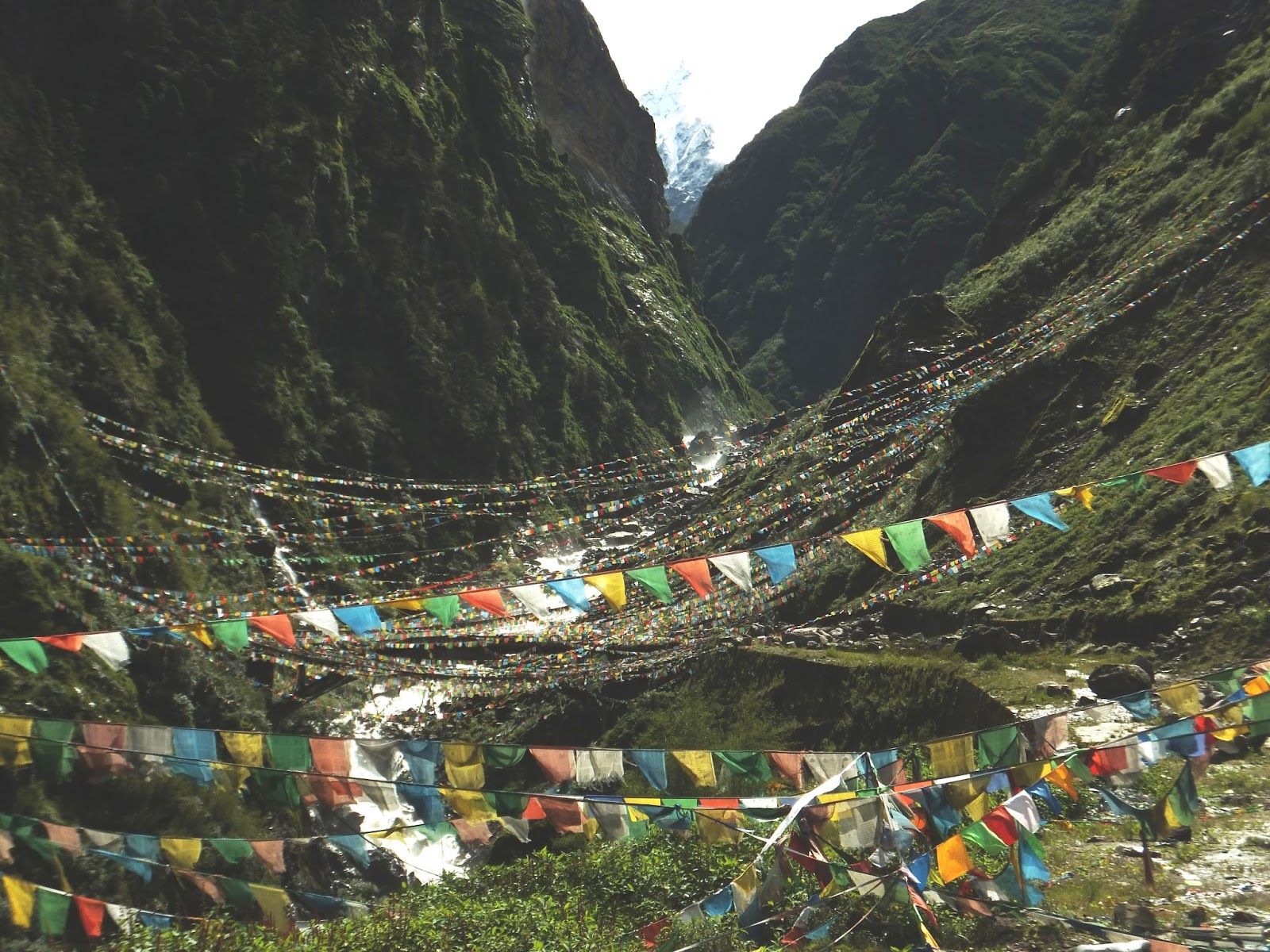
N 27.59.18 E 85.58.56 altitude 2190 meters 10392 km from Grimshaw
Yes, we dropped more than 2000 meters on our journey today through lush rain forest Zangmu is a one street border town clinging to the side of the mountain We'll leave the next part of the story (and how beautiful the rainy side of the Himalayas is) to Nepal. Here's one last picture to give you a hint.
As I am adding photos and comments to this entry, we are in Vietnam. Vietnam also has the figures that Tibet calls Snow Lions, but here they are called unicorns.
ReplyDelete